Guests: Doug Sharp and Rich Geer
Description: The dinner cruise we took on Kauai along the Na Pali coast revealed to me a little bit about the geomorphology of Kauai, and it flies in the face of the evolutionary explanation that the islands popped up in sequence over millions of years and eroded to current size.
The cruise starts in Port Allen on the southern coast of Kauai, and travels along the arid rain shadow of the northern coastal mountains. The southern edge of Kauai is rather flat. There is a massive sandy beach from Kekaha to the Polihale Beach State Park and it is part of the Barking Sands Missile Range operated by the Navy. But after the last campground, the massive cliffs begin. The cliffs along the Na Pali coast catch the clouds of the trade winds and continuously deposit rain on the mountains. Mt. Wailaele in the center of Kauai gets 40 feet of rain every year.
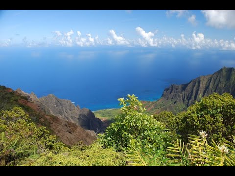
I noticed that from the west end to Mioli’l Beach, the cliffs were sheer and though there are 8 canyons on that side of the island, they are not as spectacular as those on the north end of the island. The Waimea Canyon can be seen from Hawaii Route 550, and that ends at Kokee State Park, which sits on the divide between the Na Pali Coast and Waimea Canyon, and there are two views, the Kalalau Lookout, and the Pu’u O Kila lookout. From the Pu’u O Kila lookout there is a spot where you can view both coasts: the south and the north. In the 1950’s they tried and failed to build a road to Princeville.
The north coast is where Kauai gets almost continuous cloud cover. If you want a good view, go early in the morning to the Kokee State Park views. That’s when the weather will be more favorable. There are rough trails that lead to views of the Nu’alolo Kai Beach, Awa’awaphi canyon, Honopu Beach and Kalalau beach. The Kalalau valley is a spectacular view, and the valleys east are even more spectacular and deep. Honopu is a beautiful, unspoiled beach and the only way to get to it is to swim.
The explanation I have for Kauai is that it is young. The Pacific plate that formed these islands started moving in the Aleutians, and during catastrophic plate tectonics in the flood, it rapidly popped up these islands, then slowed down. Kauai erupted first, along with Ka’ula, Niihau, Lehua, then Oahu, Molokai, Lanai, Maui, Kahoolawe and lastly the big island. The island and seamount chain from the Aleutians were built rapidly first.